Archambault Théo
|
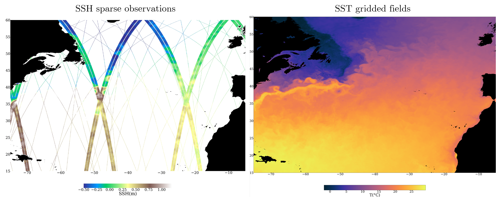
I am Ph.D. in computer science applied to oceanography, at Sorbonne University, LIP6, under the supervision of Dominique Béréziat and Anastase Charantonis. I am now working at Amphitrite, as a computer vision R&D researcher. I am interested in all research bridging geosciences and machine learning but I mainly study deep learning methods to reconstruct satellite data of the ocean surface with a particular focus on sea surface height and temperature. During my Ph.D., (manuscript), (slides), I designed deep learning models to reconstruct the Sea Surface Height (SSH) using multivariate satellite observations, notably the Sea Surface Temperature (SST). If you have any question about similar work or related matters, feel free to contact me. |
Contact: theo.archambault@amphitrite.fr, Research Gate, Semantic Scholar, Google Scholar
|
Publications
Journal
Garcia, P., Larroche, I., Pesnec, A., Bull, H., Archambault, T., Moschos, E., Stegner, A., Charantonis, A., Béréziat, D. (2025). ORCAst: Operational High-Resolution Current Forecasts. Artif. Intell. Earth Syst., 4, e250002. link , file
Archambault, T., Filoche, A., Charantonis, A.A., Béréziat, D., & Thiria, S. (2024). Learning Sea Surface Height Interpolation From Multi-Variate Simulated Satellite Observations. Journal of Advances in Modeling Earth Systems (JAMES). link , file
Thiria, S., Sorror, C., Archambault, T., Charantonis, A.A., Béréziat, D., Mejia, C., Molines, J.M., & Crépon, M. (2023). Downscaling of ocean fields by fusion of heterogeneous observations using Deep Learning algorithms. Ocean Modelling. link (ask me the file in an email)
Archambault, T., Charantonis, A.A., Béréziat, D., Mejia, C., & Thiria, S. (2022). Sea surface height super-resolution using high-resolution sea surface temperature with a subpixel convolutional residual network. Environmental Data Science. link , file
Conference
Garcia, P., Archambault, T., Béréziat, D., Charantonis, A.GloFM: a GLORYS Flow-Matching emulator for spatio-temporal ocean data assimilation. VISAPP. HAL: hal-05450893v1. link , file
Archambault, T., Filoche, A., Charantonis, A., & Béréziat, D. (2024). Pre-training and Fine-tuning Attention Based Encoder Decoder Improves Sea Surface Height Multi-variate Inpainting. VISAPP. link , file
Archambault, T., Filoche, A., Charantonis, A.A., & Béréziat, D. (2023). Multimodal Unsupervised Spatio-Temporal Interpolation of Satellite Ocean Altimetry Maps. VISAPP. link , file
Filoche, A., Archambault, T., Charantonis, A.A., & Béréziat, D. (2022). Statistics-Free Interpolation of Ocean Observations with Deep Spatio-Temporal Prior. ECML MACLEAN workshop. link , file
Archambault, T. ,Filoche, A., Charantonis, A.A., & Béréziat, D. (2022). Unlearned Downscaling of Sea Surface Height with Deep Image Prior. ICLR AI for Earth Science Workshop. link , file
Archambault, T., Charantonis, A., Béréziat, D., & Thiria, S. (2022). SSH Super-Resolution using high resolution SST with a Subpixel Convolutional Residual Network. Climate Informatics. link , file
Preprint
Garcia, P., Larroche, I., Pesnec, A., Bull, H., Archambault, T., Moschos, E., Stegner, A., Charantonis, A., Béréziat, D. (2025). ORCAst: Operational High-Resolution Current Forecasts. ArXiv, abs/2501.12054v1. link , file
Archambault, T., Filoche, A., Charantonis, A.A., Béréziat, D., & Thiria, S. (2023). Unsupervised Learning of Sea Surface Height Interpolation from Multi-variate Simulated Satellite Observations. ArXiv, abs/2310.07626. link , file
Presentations
In conferences
EGU 2024: Oral presentation (on site): slides , abstract
VISAPP 2024: Oral presentation (on site): slides
VISAPP 2023: Poster presentation (on site): poster
RFIAP 2022: Poster presentation (on site): poster . It is an accepted resubmission of my work in Climate informatics 2022.
Climate Informatics 2022: Oral presentation (online): slides .
In seminar and study groups
Formal-v2 launch day 2024 : Oral presentation (on site): link slides
Telecom Paris Seminar 2023: Oral presentation (on site): slides
Formal-v2 launch day 2023 : Poster presentation (on site): link
SAMA/SCAI study group 2022: Oral presentation (on site): slides